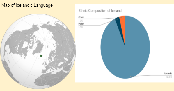
1. The chart and map above suggest that Iceland is best classified as which of the following political entities?
- a. Autonomous Region
- b. Multistate Nation
- c. Multinational State
- d. Nation-state
- e. Stateless Nation
b. This is WRONG because Icelandic culture is dominant exclusively within Iceland and does not have a large presence in surrounding countries (of course this is helped by the physical geography of Iceland being an island).
c. This is WRONG because the stimulus material shows very little diversity within Iceland. The overwhelming majority of people in Iceland are ethnically Icelandic.
d. This is CORRECT because the boundaries of the country of Iceland match the boundaries of the Icelandic nation. There are not only few people within Iceland who are not ethnically Icelandic, but there are also few Icelanders outside Iceland.
e. This is WRONG because the Icelandic people have dominance and control over a state - Iceland.
- The partition of British India occurred in 1947.
- The partition was based on religious majorities in provinces.
- The partition displaced millions of people on the basis of religion.
2. The above information describes the major development in the creation of boundaries between India and Pakistan. In addition to being a subsequent boundary, the boundary between the two states is also described as a(n)
- a. Antecedent boundary
- b. Consequent boundary
- c. Superimposed boundary
- d. Relic boundary
- e. Geometric boundary
b. This is CORRECT because the boundary was created on the basis (as a consequence) of cultural differences.
c. This is WRONG because, although India was colonized prior to the partition, upon independence the British gave the states within former British India the option to join India or Pakistan.
d. This is WRONG because the boundary is still functioning.
e. This is WRONG because the boundary is not a straight-line boundary.
Use the following map to answer questions 3 and 4.
Map of Kurdish Population
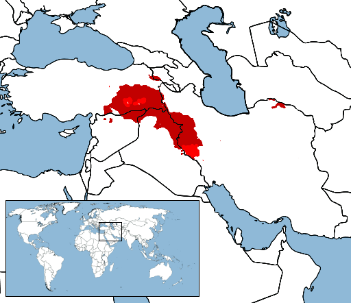
Map Source: https://commons.wikimedia.org/wiki/File:Kurdistan_map.png
3. The distribution of the Kurdish population on the map illustrates that they are a(n):
- a. Autonomous Region
- b. Multistate Nation
- c. Multinational State
- d. Nation-state
- e. State
b. This is CORRECT because the Kurds are a cultural group (nation) and they are spread across multiple sovereign political units (states).
c. This is WRONG because while some of the states in which the Kurds appear can be considered multinational states, there is more than one state shown with dominant Kurdish population and the Kurds do not have a state.
d. This is WRONG because while the Kurds are a nation they do not have a state at all, much less a state that matches their distribution.
e. This is WRONG because the Kurds do not have a political unit (state) which they control.
4. Which of the following statements best explains the reason the Kurdish population has not been successful in establishing an independent Kurdistan?
- a. The Kurdish population is not culturally unified and factions within the Kurds have prevented a unified effort to create Kurdistan.
- b. The Kurdish population in Syria has been subjected to irredentism by Iraq and therefore unable to make progress towards independence.
- c. The Kurdish population has been subjected to neocolonial control by United States-based oil companies, acting as an economic barrier to independence.
- d. The Kurdish population is too small to become a viable, independent country. If Kurdistan were to be an independent country it would be one of the smallest in the world.
- e. The Kurdish population has large numbers in Turkey, Syria, Iraq, and Iran meaning that for Kurdistan to be created each of those countries would have to give up some territory and resources.
b. This is WRONG because Iraq has not tried to acquire territories in Syria and, if they did, this would still not apply because the Iraqi people are seen as distinct to the Kurdish population.
c. This is WRONG because oil companies in the United States have not acted as a barrier to the creation of Kurdistan and, in fact, many oil companies have recently pulled out of Kurdistan.
d. This is WRONG because there are around 30 million Kurds living in the areas shaded on the map. An independent Kurdistan would rank in or near the top 50 in terms of population size.
e. This is CORRECT because each of the countries with significant Kurdish populations would have to relinquish territory and resources for Kurdistan to be created.
Map of North Korea, South Korea, Japan
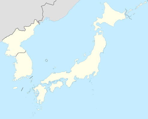
Source: https://upload.wikimedia.org/wikipedia/commons/e/ec/Japan-Korea_adm_location_map.svg
5. Japan and South Korea both lay claims to many islands, including some that are claimed by both countries. Which of the following best explains how the United Nations Convention on the Law of the Sea (UNCLOS) may influence the significance of islands to both countries?
- a. The claims to islands would also grant the country exclusive economic zones up to 200 nautical miles.
- b. The claims to islands also include large populations, significantly increasing the potential workforce of each country.
- c. The claims to islands also grant the country naming rights to the bodies of water in which they are located.
- d. The claims to islands are also based largely on ethnonationalism and help unify each respective cultural group.
- e. The claims to islands would also extend the political influence of each country in order to help contain the influence of China.
b. This is WRONG because the islands do not contain large populations therefore the economic impact as a result of increasing the workforce is negligible.
c. This is WRONG because possessing islands in a body of water does not give enhanced naming rights. Naming is a complex, time consuming process focused on recognition by the international community.
d. This is WRONG because the claims to the islands are not focused on the ethnicity of inhabitants as the basis for claims. This answer would suggest that claims are irredentist in nature.
e. This is WRONG because claiming the islands does not necessarily extend political influence.